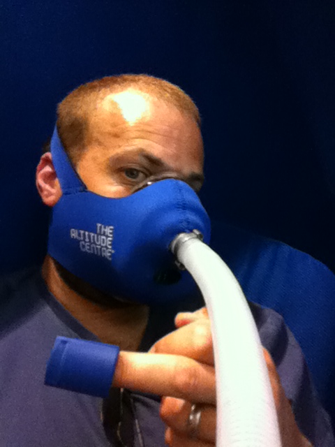
 I’ve just started a course of Intermittent Hypoxic Exposure (IHE) using the Altitude Centre’s POD in Manchester’s Ellis Brigham store. It works by allowing me to breathe rarefied air and so expose me to lower oxygen levels with the aim of triggering some physiological changes to help me “pre-acclimatise” before I get on to Kilimanjaro. I’ll be trying to get a 40 minute session in each day until we leave a week on Friday. I don’t know to what degree it’ll help but I’m pretty much happy to try most things to give me the best chance of reaching the summit!
Category Archives: Training
Langdale Pikes
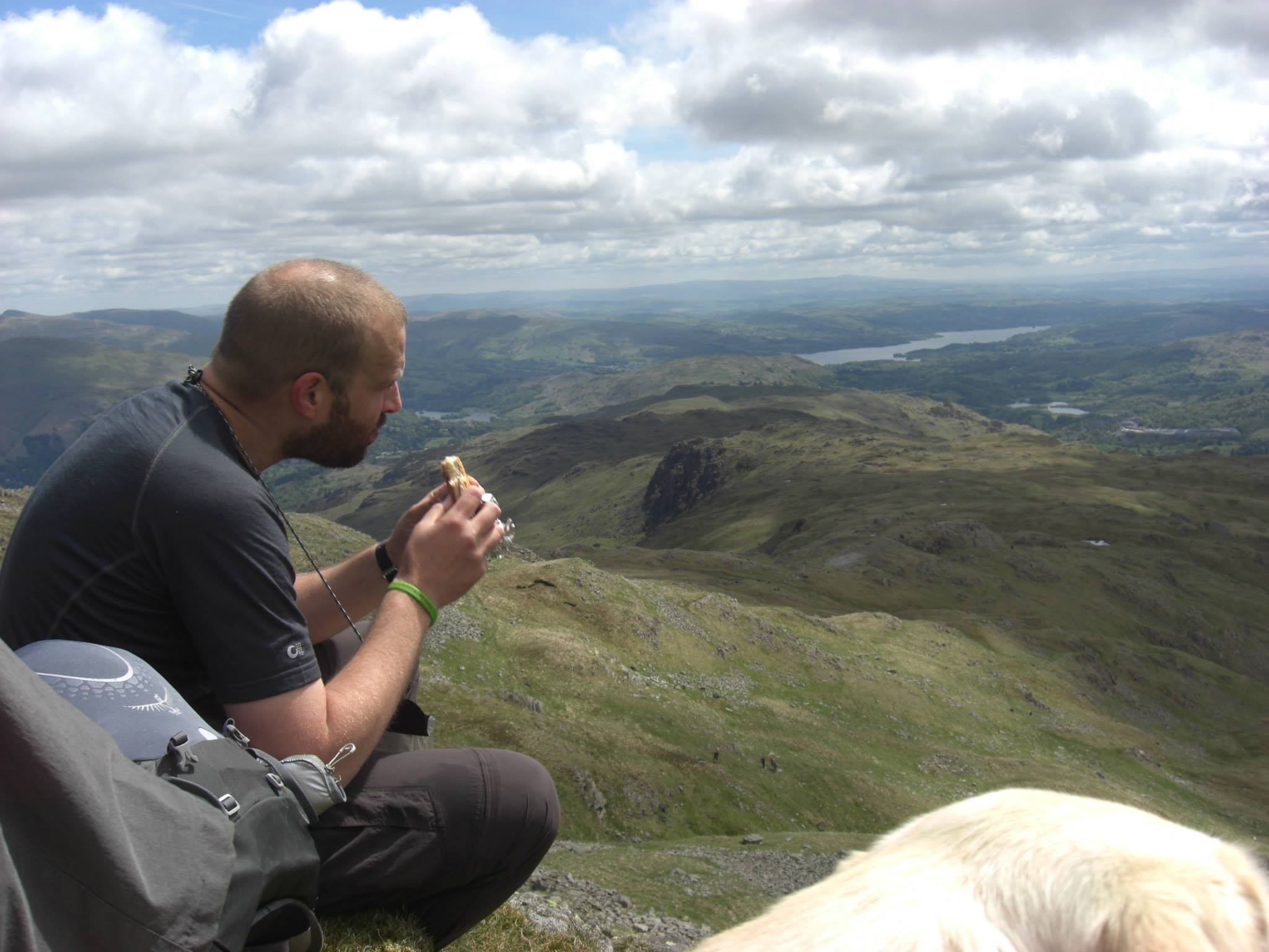 June’s here and it finally felt like summer might be on its way as I planned our penultimate training hike. I selected a Lake District route around the Langdale Pikes and Bowfell , armed myself with a map and compass and arranged with Paul and Debbie to meet at 9.30am at the New Dungeon Ghyll hotel. Jeff wasn’t free to join us this weekend but we’ll get the whole team together for one last walk next weekend before we head out to Tanzania.
It was a little overcast but presently warm as we set off , each of us enjoying being able to wear just T-shirts. I led the way out of the car park and with minutes we were onto the pathways and picking our way along and up a rocky climb alongside a stream. After about 30 mins of hard work we were all hot and ready for a rest as we came up and over a crest to see the Stickle Tarn. This wasn’t in the plan but I’d manage to take us up a more northerly track. Still it was a pleasant place to stop for a snack and drink as we studied the map and worked out a revised route. I’m definitely going to book myself of a navigation training course when I get back from Kili.
We left the tarn for High Raise to the north and climbed over some very wet ground and ten onto some pretty steep slopes. We stopped off at Sargent Man to take a rest and shelter from the wind and have a drink. We were rewarded with stunning views to the south and east over the Lake District and out over Morecambe bay as we basked in the sun’s warming rays. On went the fleeces as we got back into the wind and made our way over to High Raise’s trig point.
We then turned south west and headed down to pick up the Cumbria way foot path with the intent of looping over to Angle Tarn. However we missed the path and so ended up carrying on to follow stake gill as if flowed own into Mickleden Beck at the base of the imposing Langdale fell and its many stony crags. Our knees were glad to find the valley floor (sometimes going down is just as tough as going up) and we waked parallel to the Beck as it led us back the last few miles to the car park.
At just over 8 miles this wasn’t a massively long walk but it had a lot of steep ascent and descents which all help work the muscles we’ll be needing for Kili in a couple of weeks. I’ve post some photo on the Kilimattjaro facebook page and the climb stats and map.
Snowdon
 Last weekend’s training hike was Wales’ highest mountain, Snowdon. Martine and Sophie joined me and our new (to us) caravan (we’ve had enough of tents in the UK weather!) as we spent the bank holiday long weekend in Snowdonia. Paul, Debbie and Wallace the Labrador stopped in their campervan on the same site.
Saturday morning was glorious, warm and blue skies as Paul, Debbie and I set off down the road to pick up the Snowdon ranger path a few miles away to start the long climb up to the 3560ft (1085M) summit. After the initial climb and about 4.5 miles into the hike we stopped looking down over the Llyn Ffnnon-y-gwas reservoir. It was time for lunch and where Wallace decided that he liked the look of Paul’s ham sandwich and swiftly grabbed it and wolfed it down in the blink of an eye.
It was then on to the hard stuff as the path became rocky and steep and it zig-zagged up toward the peak where it intercepted the LLanbaeris path and mountain railway track to the summit. As we rose higher the temperature dropped and we even saw patches of snow hiding in the rocks along the ridgline. The views were spectacular looking our across both sides of this impressively high (by UK standards) mountain. The peak was very busy but we took the obligatory photos as the summit trig point before grabbing a hot drinks and snack and donning gloves and hats.
Rested and refreshed we followed the mountain train track down towards Llanberis for a few miles before turning off westwards around Hebron station to make our way around the lower flanks of Moel Eilio and then descending back down to our campsite.
At just over 14.5 miles this was a long walk but whilst tired and with empty hydration bladders we kept up a good pace and all felt good the day after. I’ve posted the climb stats and some photos of the day.
Kentmere Horseshoe
 “I’m glad it was cloudy so I couldn’t see how much we had to do” said one of team after our 11.6 mile walk around the peaks of Kentmere in the southern eastern corner of the Lake District. It was a long, steady ascent up to the first peak and we were soon in the mist and getting damp. On came the waterproofs as we stopped for an early lunch.
After sandwiches and a hot drink we began off along the ridgeline up and down the horseshoe of peaks. Visibility on top was no more than 25 meters, the ground damp and after while the path became hard to identify. Out came the maps, compass backed up by my trusty iPhone GPS app! Eventually we got ourselves fixed and back on the path as we descended to lower ground and below the cloud. We were now rewarded with stunning views of the Kentmere valley and the peaks we’d just traversed along.
We completed the circuit tired but in good spirits. On the way home Jeff and I polished off Kendal mint cake and flapjacks after our long day in the hills. I’ve posted the climb stats and some photos on facebook.
Wet Wherside and Inclement Ingleborough
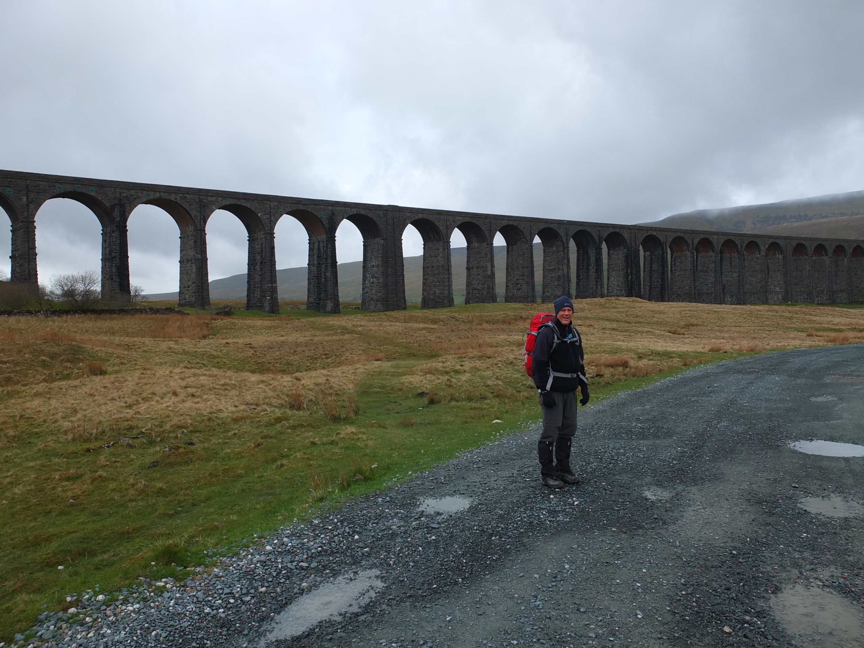 Last Sunday Jeff and I took on a Whernside and Ingleborough double whilst Paul and Debbie sunned themselves in Dubai (Envious? Me?). I think they had the better deal weather wise.
We parked up just outside the Ribbleshead viaduct and set off around 9.30 in over cast and breezy conditions. Initially heading north westerly following the train line before turning to begin the climb up to Whernside’s ridge. By this point we were in the mist and drizzle so out come the waterproofs. At this point I realise my Gortex over-trousers are at home – big time fail! Around 11.30am we make a quick stop at the summit wind shelter where I grab a cup of tea and an energy bar and then we’re off along the ridge and then down the valley where we stop to adjust kit and snaffle down a sandwich.
It’s now windy and really raining – cold on the face as I try to reduce the presented surface area by receding well into my coat’s hood. We cross just north of Chaple-le-Dale and begin our way up towards Inglebrough. Once over the fells and past some pretty impressive looking pot holes we climb back into the mist and up a very steep and wet path of rock steps up to the north easterly side of set of Inglebourgh upper slopes. From there it’s a short climb to the south east to reach the summit trig point and the welcome respite of the wind shelter where we finish the last of our hot drinks.
By this point my lower half is saturated and I’m cold so I’m glad to get moving again. The next hour or so we move north easterly along the upper slopes of Inglebourgh, across Southern Scales Fell and Park fell before descending down to pick up the road back to Ribblehead.
In an effort to conserve battery life I rather smartly stuck my phone into aeroplane mode forgetting that this also disables the GPS. This means that I didn’t record any climb stats for this hike but Jeff estimated our route to be around the 14miles mark. We finished the route at around 4.30pm which is fairly respectable time. If we kept that kind of pace up we should be able to nail the Yorkshire 3 peaks under the 12 hour mark – a challenge I’d like to attempt but perhaps save for after the Kili trip as I don’t seem to be getting any takers from the rest of the team just yet. Not too many more weekends on the hills as we leave for Tanzania in 30 days’ time!
“I’ve had a good idea”

During an evening training hike on Pendle Hill Jeff’s good idea was to ignore the paths for the second ascent and just go directly up the hill. It was ***** steep and had my calves were complaining as I hauled myself up. It’s pretty clear to spot on the climb stats! Not long to go so we’re getting as many hikes in as possible. I may not blog on each and every one of the weekday short hikes but you should see the climb stats get tweeted if you follow @kilimattjaro.
Anyway, next time Jeff has a “good idea” I’m going to play deaf… 😉
A Double Pendle To Go Please
 Tuesday evening Jeff and I took quick jaunt up and around Pendle Hill. We were having so much fun we went up and down it twice! As it’s only about a 25 minute drive away it’s a great evening hike as we approach the final weeks of training. Weather was a lot milder and very little wind compared to our previous Pendle hike.
We set off up the eastern flank of hill around 7pm taking the right hand stepped path. I kept my poles on my pack to really give my legs the full benefit of the climb. Our pace was good and we were both breathless and red by the time we reach the peak plateau around 25 minutes later.
A quick drink and a few moments to take in the views across Lancashire and up and over to the Yorkshire Dales and we were off on our way down again. Jeff led the way as we took a direct route down Pendle’s steep eastern slopes. Here the poles were most definitely needed for stability and well laced footwear to stop your foot banging into the boot’s toe box. Underfoot were spongy moss and fern interspaced with small sections of peat and rocks. I’ve ready the descent from Kilis peak is also very steep and full off loose scree so whilst the descent angle might be similar the materials underfoot will be very different. I took a “zig zag” approach to working down to shallow off the angle but managed to keep up a quick rate down until we picked up another assent path.
This time we climbed up a longer and slightly shallower path back to the top before another quick rest at the summit trig point. From there was back down our initial path and back to the car. A short hike in terms of distance but it was almost all either climbing or descending so good exercise for us both. I’ve posted a few photos to the Kilimattjaro Facebook page and you can see climb stats here.
With our Kilimanjaro trip now just 45 days away we’re in our peak training (pun slightly intended 😉 )period.
Hiking in Hope
 A 7.45am start as Jeff picks me up for the drive over to Hope in the peak district where we met up with Paul and Debbie around 9.30am. Conditions were mild but windy as we got kitted up for the circular route around the Hope valley which we expected to be around 8 miles in distance.
The first section was low level across fields as we made our way over to the neighboring town of Castleton. From there we began our ascent up the side of the valley up the narrow and rocky “limestone way” up past Peveril castle. Progress was noticeably slower on this steep, wet and tricky section as the ground was difficult to get stable footings on. After what felt like forever the limestone walls opened out and we made our way back onto open ground across higher fields dotted with sheep and lambs.
A few more miles in brought us out over a high fell road and to the base of Mam Tor where we paused for lunch. Looking up at the route to the summit we were envisaging burning calves and puce faces however as we got closer we found that whilst is was certainly steep in places the inclined felt more manageable due perhaps in part to the stone path work that had been laid. The views from the blustery top were magnificent as we gazed back down into Hope valley on one side and over the Edale valley to the other.
After a quick photo stop around the summit trig point we were off along the hills ridge line for the next few miles as we descended and then rose again over multiple smaller peaks. In this manner we worked along the northern side of Hope valley until we made our final descent back to our starting point in Hope village.
From today’s hike I think everyone’s fitness is coming on nicely and we all seem to be handling ourselves and equipment with aplomb. With just over 6 weeks before we leave for Kilimanjaro we only have a four more weekends where we’re all free to train together.
I’ve posted the climb stats (which seem shorter than 10 miles Paul’s phone recorded using the same app) and uploaded photo to the Kilimattjaro facebook page.
Fancy A Quickie Up Darwen Tower?
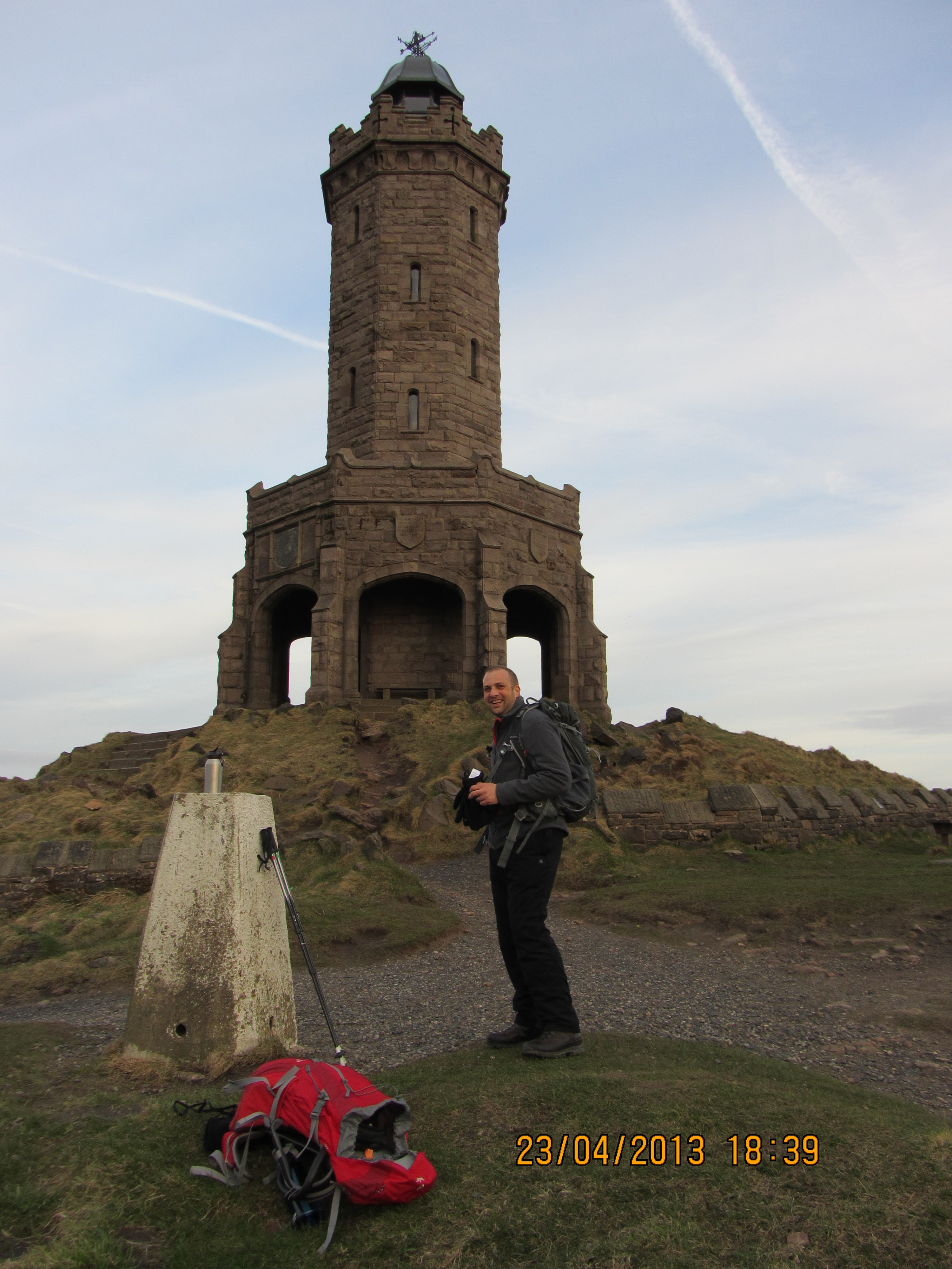 Jeff and I got a cheeky little evening hike in today up to Darwen Tower. The circular route was about 4 miles and took around 1 hour 15 mins although the climb stats from my phone say otherwise for some reason (I think I was in “bike” mode rather than “hike”). There was a good mix of elevation changes so we got a bit of a work out. From the tower we enjoyed pleasing vistas over Lancashire to the North West coast and across to Pendle Hill in the North East. I’ve posted a few photos in an album on the Kilimattajro facebook page.
We’re planning to get more of these weekday sessions in as the nights get longer and our June Kili climb approaches – 54 days to go at the time of writing!
Night Hike
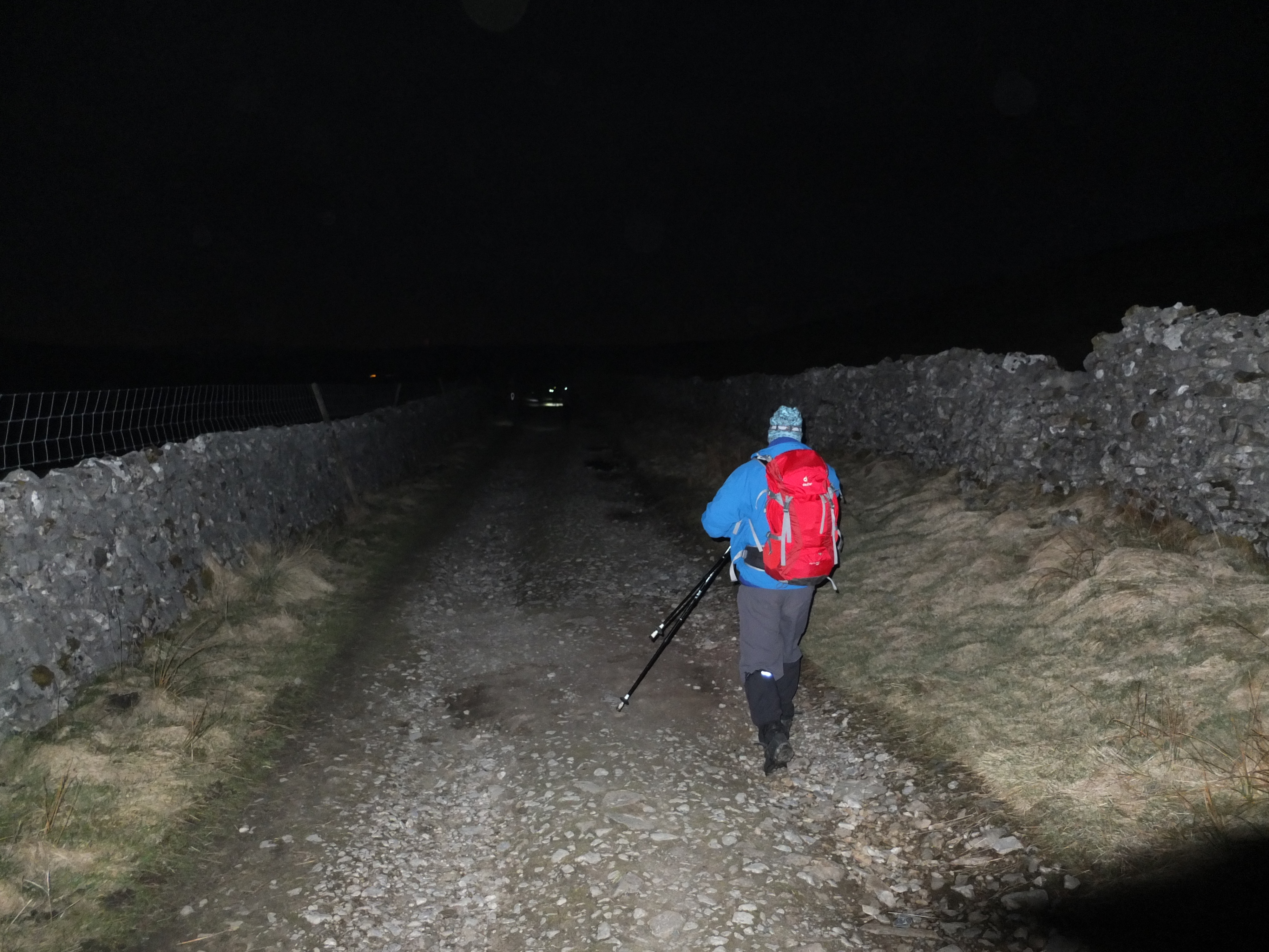 Last night we did a night hike over our perennial favorite Pen-y-ghent organised by Mark Reid of Team Walking. We booked this walk many months ago with a view to getting some prior experience of handling ourselves and kit in low light as preparation of the final ascent night on Kili.
We met up with Mark and the rest of his group at the Crown pub in Horton-in-Ribblesdale around 6pm and Mark gave us all a quick briefing around the route, expected timings and also the differences to expect when walking at night such as allowing your night vision to develop by protecting your eyes from direct light, using your other senses to augment your understanding of your environment etc.
Conditions were mild and the first part of the ascent was done just in T-shirt and long-sleeved base layer top but as we reach higher ground the sun began to get low in the sky and the temperature dropped. Off comes the backpack and outcomes my fleece. I’m now getting reasonably adept in changing my layers quickly and more importantly anticipating when to do so. This means I’m keeping comfortable without overheating too much. We reached the summit just after 8pm and stopped for a hot drink and snack as the sun set.
All the snow has now gone and the steeper section of initial descent is now much easier and quicker to get down although you still need to be controlled in your pace over the areas of looser ground. There was still plenty of ambient dusk light as we came off the mountain but as we reach the lower flanks the light began to fade and out came the head torches.
Most of the pathways are limestone and so of a light colour – that certainly helped pick them out in the moonlight / torchlight. We took a 15 minute detour to walk over to hull pot – an impressively sized sink hole when the water course disappears underground into the local cave systems. While we gained a sense of scale under the moonlight I think I’d like to go back for a look and photography of it during the day.
On the final few miles back into the village we turned off the torches and just walked in the moonlight. Most of the pathways are limestone and so of a light colour – that certainly helped pick them out in as we made swift progress. I’ve posted the hike’s map and stats and some photos on my Kilimattjaro facebook page.
Throughout the hike Mark interjected our stops with commentary about the landscape, questioning the group on our thoughts and understanding of the environment we were in. He’s clearly a passionate advocate of the benefits of getting outdoors and his views and philosophies come shining through in conversation.
Things I learn from this hike
- With just a little moonlight you don’t really need a torch at all.
- Low power mode on my head torch is more than adequate to illuminate my foot fall
- I don’t yet know how to take photographs in night time conditions and so need to read up on that
