Kilimattjaro

My journey to reach the roof of Africa


Leave a comment

Kilimanjaro Equipment Review

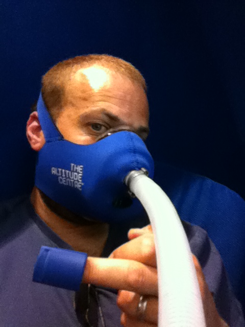
During the planning and preparations for my Kilimanjaro trip I was obsessed with gear and equipment.  I’m sure any would be / in preparation Kili climber will figure out their waterproof / cold weather gear so here’s a summary of a few other items that worked particularly well for me and some that I found less useful..

I liked…

airlok_456_456autoAlpkit AirLok Dry Bags.  On our 1st day of hiking we had rain on the lower slopes – these kept all my gear bone dry. I had a selection of sizes and found them really useful for keeping stuff organised in my back bag and porter duffel – just the job when you’re scrambling around with limited time to pack up and strike camp in a morning.  I’m still using them today when I travel.  Low prices and good service from Alpkit make these one of the best gear buys of my trip.

meco_120_ls_tee_mayaRab MeCo Base Layers.  Comfortable, light weight and stink free – just the job. I had a T-shirt, long sleeve, Boxers and full length pants.

nailbrush

Nail Brush. Kili’s dust gets everywhere – give yourself a fighting chance of keeping your hands clean for meals. Take something to scrape the dirt from under your finger nails too!

KJ311_Rain-Hat_FRONT-RIGHT-374x374
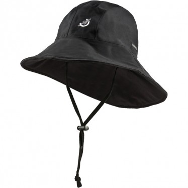
Seal Skinz Trail Hat. Kept the sun and rain off me nicely on the lower slopes of Kili. Lightweight and relatively low cost to the alternatives I looked at. Not the most glamorous item I ever wore though – still, screw fashion – stay dry / avoid sun burn!

magic coin towels

Magic Coin Disposable Pock Towels. Cheap as chips, takes up very little space and an absolute god send. A new flannel for every bowl of washing water!  Inexpensive cleanliness…

socksHeat Holders Socks. Warm feet at night – ‘nuff said.

STS_AREACTEX-TR-Thermolite-Reactor-Extreme-308x308

Thermolite Reactor Extreme Sleeping Bag Liner. I rented a sleeping back from my climb company so I wanted to ensure I had a liner for extra warms / cleanliness. As it happens the sleeping bags provided were clean and warm but this lightweight / low pack volume liner ensured I was toasty every night on Kili.

x10Fuji X10 Camera  (superseded by the X20). Compact, good battery life (took 2, only needed 1), great lens. I’m no photography expert so my lovely wife who knows about these things choose the Fuji for me, particularly because of the lens range from macro to semi-wide angle. Loads of features yet idiot (me) proof.  You’ve got to capture the trip, right?  Cool retro styling. A top gadget.
A81100261212
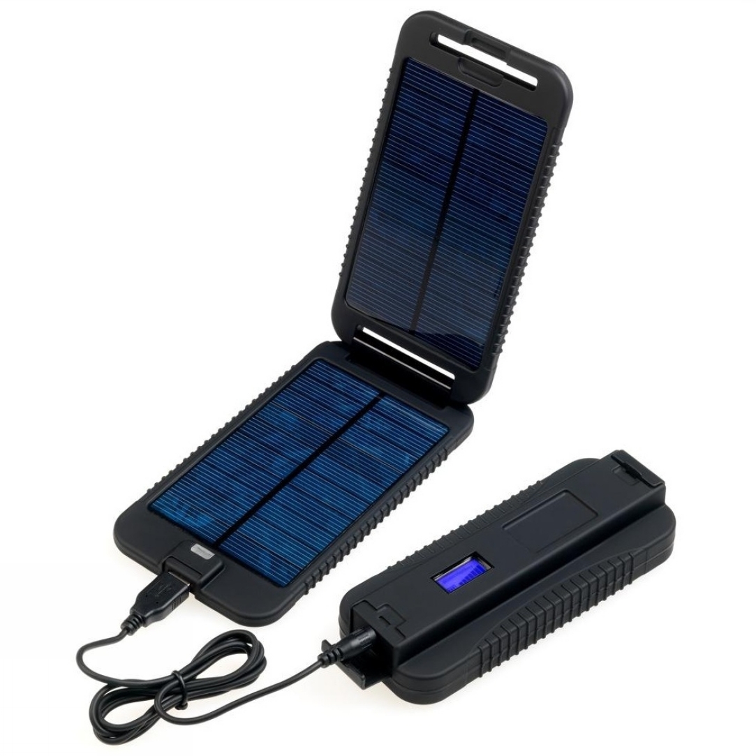
Power Monkey Extreme Solar Charger / Battery.  Kept my iPhone and iPad charged for the whole trip. I used a GPS app to track my climb. Didn’t manage to make any calls but did get the odd patch of cell phone coverage to send and receive SMS. Easy to use and robustly built but a little heavy because of the larger battery capacity– you might find lighter versions if you just want to charge a phone

I was less impressed with or didn’t use…

altivitAlti-Vit Vitamin supplements.  I didn’t feel that these made a difference for me as I still felt the effects of altitude (headache, nausea) most days. Your millage may vary of course.
headpadsHi-Gear Heat Pads – didn’t feel too warm on summit night, maybe due to lower oxygen levels (catalyst for heating process). Had to take gloves off to open / activate – so your hands get colder  just when you’re at the point of already needing to warm them up. May work better at lower altitudes, haven’t tested.

STS_ASTOOL-Nylon-Pocket-Trowel
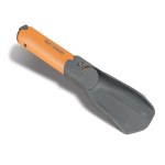
Pocket Trowel- Reinforced Nylon. I didn’t need to poop en-route during the day’s hikes so this never got used. I’m not sure it would have been robust enough to dig into Kili’s slopes though.

CanteneNalgene Wide-Mouth Canteen – This was going to be my “pee bottle” for when I didn’t want to leave the warmth of my sleeping bag at night. Once on the mountain I decided  that  didn’t feel like risking any in-bed spills or leaks so I just got up when nature called (which can be very quickly when you’re just started taking Diamox!). Seemed like a perfectly functional and robust flat-pack bottle – I just didn’t need to use it in the end.


1 Comment

Time to Go

Right today’s the day then. We leave this afternoon for Istanbul and then onwards to Tanzania arriving early in  morning Sunday. We begin our climb on Monday taking an 8 day Rongai route – you’ll be able to keep an eye on how we’re doing via the climb tracker. I’m taking my iPad / iPhone but I don’t know if I’ll be able to blog during the trip. Keep an eye on Twitter though as I might get an odd update out on that.

Didn’t get chance to write up on my packing kit list but I’ll certainly review what worked / what was superfluous once I get back. Finally, thanks to everyone who’s supported the project and donated to PSC Support. I’m off to fly my PSC Support flag at 19,340ft next week – wish me luck. Thanks!


2 Comments

Talking To Myself

motivationletterJust a few days before we leave and so as you might expect the trip and the challenge ahead is never far from my thoughts. I feel good about the preparations and training I’ve done – my fitness is better than it’s been for many years and my weight is significantly lower than a year ago. I’ve also obsessively read and research anything I can find on climbing Kilimanjaro, trekking gear, hiking skills and high altitude physiology /medicine. I’m both exited (like a kid waiting for Christmas type excited) yet wondering what lies ahead. I know it’s likely to be tough in places and it’s the personal challenge to see what I can do that played a part in my first thinking about “doing Kili”.

Yesterday the team, our families and I did a local short walk and then shared a meal and drinks in the evening sun. It was great for us all to spend some time relaxing and talking about the trip ahead of us. Today I’m off for another IHE session and tomorrow is my last training session in the gym. I’m then into resting until we depart on Friday – the sports performance professional’s call this “tapering” – I call it taking it easy and eating loads of carbs before the climb 😉

The other aspect of my Kilimanajaro challenge was of course to raise funds and awareness for PSC Support. I’ve been delighted, amazed and humbled at people’s good will and generous donations – so much that I have had to rise the fund raising target couple of times. Jeff in our team has also been fund raising too and between us we’ve already raised in excess of £6,000 which is absolutely fantastic. Thanks to everyone who has helped make that happen. Of course if you’ve not yet donated there’s still time to help and every single penny will go to good use to help those affected by PSC.

Meeting my half of the sponsorship bargain will be a significant point of motivation when I’m on the mountain. To help reinforce my commitment and in an attempt of some amateur psychology I’ve produced a Motivation Letter to myself to remind me why I’m doing this and who’s supporting me. I’ll be taking a laminated copy with me in my back pack and plan to read it daily. So if you’ve sponsored the climb you’re going to the summit with me both in my grateful thoughts and on my motivation sheet. I’ll produce a final one on Thursday night before as I pack so why not get you name on there by sponsoring me?

This week’s main challenge will be how on earth do I pack all my gear and keep within my weight limits for the airline and mountain porters? I’ll write up a separate blog on my Kili Kit list and packing – it’ll be interesting to see what I actually find useful vs all the stuff I’d like to take.


6 Comments

Exposure

photo3I’ve just started a course of Intermittent Hypoxic Exposure (IHE) using the Altitude Centre’s POD in Manchester’s Ellis Brigham store.  It works by allowing me to breathe rarefied air and so expose me to lower oxygen levels with the aim of triggering some physiological changes to help me “pre-acclimatise” before I get on to Kilimanjaro.  I’ll be trying to get a 40 minute session in each day until we leave a week on Friday.  I don’t know to what degree it’ll help but I’m pretty much happy to try most things to give me the best chance of reaching the summit!


Leave a comment

Langdale Pikes

964072_10151635059494421_245297392_oJune’s here and it finally felt like summer might be on its way as I planned our penultimate training hike.  I selected a Lake District route around the Langdale Pikes and Bowfell , armed myself with a map and compass and arranged with Paul and Debbie  to meet at 9.30am at the New Dungeon Ghyll hotel.  Jeff wasn’t free to join us this weekend but we’ll get the whole team together for one last walk next weekend before we head out to Tanzania.

It was a little overcast but presently warm as we set off , each of us enjoying being able to wear just T-shirts. I led the way out of the car park and with minutes we were onto the pathways and picking our way along and up a rocky climb alongside a stream. After about 30 mins of hard work we were all hot and ready for a rest as we came up and over a crest to see the  Stickle Tarn. This wasn’t in the plan but I’d manage to take us up a more northerly track. Still it was a pleasant place to stop for a snack and drink as we studied the map and worked out a revised route. I’m definitely going to book myself of a navigation training course when I get back from Kili.

We left the tarn for High Raise to the north and climbed over some very wet ground and ten onto some pretty steep slopes. We stopped off at Sargent Man to take a rest and shelter from the wind and have a drink. We were rewarded with stunning views to the south and east over the Lake District and out over Morecambe bay as we basked in the sun’s warming rays. On went the fleeces as we got back into the wind and made our way over to High Raise’s trig point.

We then turned south west and headed down to pick up the Cumbria way foot path with the intent of looping over to Angle Tarn. However we missed the path and so ended up carrying on to follow stake gill as if flowed own into Mickleden Beck at the base of the imposing Langdale fell and its many stony crags.  Our knees were glad to find the valley floor (sometimes going down is just as tough as going up) and we waked parallel to the Beck as it led us back the last few miles to the car park.

At just over 8 miles this wasn’t a massively long walk but it had a lot of steep ascent and descents which all help work the muscles we’ll be needing for Kili in a couple of weeks.  I’ve post some photo on the Kilimattjaro facebook page and the climb stats and map.


2 Comments

Snowdon

DSCF0788Last weekend’s training hike was Wales’ highest mountain, Snowdon. Martine and Sophie joined me and our new (to us) caravan (we’ve had enough of tents in the UK weather!) as we spent the bank holiday long weekend in Snowdonia. Paul, Debbie and Wallace the Labrador stopped in their campervan on the same site.

Saturday morning was glorious, warm and blue skies as Paul, Debbie and I set off down the road to pick up the Snowdon ranger path a few miles away to start the long climb up to the 3560ft (1085M) summit. After the initial climb and about 4.5 miles into the hike we stopped looking down over the Llyn Ffnnon-y-gwas reservoir.  It was time for lunch and where Wallace decided that he liked the look of Paul’s ham sandwich and swiftly grabbed it and wolfed it down in the blink of an eye.

It was then on to the hard stuff as the path became rocky and steep and it zig-zagged up toward the peak where it intercepted the LLanbaeris path and mountain railway track to the summit. As we rose higher the temperature dropped and we even saw patches of snow hiding in the rocks along the ridgline. The views were spectacular looking our across both sides of this impressively high (by UK standards) mountain.  The peak was very busy but we took the obligatory photos as the summit trig point before grabbing a hot drinks and snack and donning gloves and hats.

Rested and refreshed we followed the mountain train track down towards Llanberis for a few miles before turning off westwards around Hebron station to make our way around the lower flanks of  Moel Eilio and then descending  back down to our campsite.

At just over 14.5 miles this was a long walk but whilst tired and with empty hydration bladders we kept up a good pace and all felt good the day after.  I’ve posted the climb stats and some photos of the day.


Leave a comment

Kentmere Horseshoe

IMG_0216“I’m glad it was cloudy so I couldn’t see how much we had to do” said one of team after our 11.6 mile walk around the peaks of Kentmere in the southern eastern corner of the Lake District.  It was a long, steady ascent up to the first peak and we were soon in the mist and getting damp.  On came the waterproofs as we stopped for an early lunch.

After sandwiches and a hot drink we began off along the ridgeline up and down the horseshoe of peaks. Visibility on top was no more than 25 meters, the ground damp and after while the path became hard to identify. Out came the maps, compass backed up by my trusty iPhone GPS app! Eventually we got ourselves fixed and back on the path as we descended to lower ground and below the cloud. We were now rewarded with stunning views of the Kentmere valley and the peaks we’d just traversed along.

We completed the circuit tired but in good spirits. On the way home Jeff and I polished off Kendal mint cake and flapjacks after our long day in the hills. I’ve posted the climb stats and some photos on facebook.


Leave a comment

Goals that go up and down

goalsIn September last year I set myself a number of goals around the Kilimanjaro challenge and with our departure 28 days away here’s a quick review of where I’m at…

Fundraising Target: £4,000 – Achieved. People have been so generous in their support and donations that we recently got over the £4,000 mark. So what next? Increase the target of course! I’m now going to see if we can make it up to £4,500 – that would be brilliant. There is so much work to be done and opportunity to make a difference to those affected by PSC that PSC Support will make great use of every single penny and cent donated.

Weight Target 14 Stone –More to do. I’m hovering around the 14stone 5lb mark at present. I’m doubling up my gym sessions with Kristy my personal trainer for the remaining weeks before the tip. To be honest I’m more concerned about getting my fitness as good as possible and the weight loss is really a consequence of that rather than the main goal.

Age Target 42:  On track. I’ll be 42 the day after we come off Kilimanjaro if all goes well!


2 Comments

Wet Wherside and Inclement Ingleborough

DSCF0766Last Sunday Jeff and I took on a Whernside and Ingleborough double whilst Paul and Debbie sunned themselves in Dubai (Envious? Me?). I think they had the better deal weather wise.

We parked up just outside the Ribbleshead viaduct and set off around 9.30 in over cast and breezy conditions. Initially heading north westerly following the train line before turning to begin the climb up to Whernside’s ridge. By this point we were in the mist and drizzle so out come the waterproofs. At this point I realise my Gortex over-trousers are at home – big time fail!  Around 11.30am we make a quick stop at the summit wind shelter where I grab a cup of tea and an energy bar and then we’re off along the ridge and then down the valley where we stop to adjust kit and snaffle down a sandwich.

It’s now windy and really raining – cold on the face as I try to reduce the presented surface area by receding well into my coat’s hood. We cross just north of Chaple-le-Dale and begin our way up towards Inglebrough.  Once over the fells and past some pretty impressive looking pot holes we climb back into the mist and up a very steep and wet path of rock steps up to the north easterly side of set of Inglebourgh upper slopes. From there it’s a short climb to the south east to reach the summit trig point and the welcome respite of the wind shelter where we finish the last of our hot drinks.

By this point my lower half is saturated and I’m cold so I’m glad to get moving again. The next hour or so we move north easterly along the upper slopes of Inglebourgh, across Southern Scales Fell and Park fell before descending down to pick up the road back to Ribblehead.

In an effort to conserve battery life I rather smartly stuck my phone into aeroplane mode forgetting that this also disables the GPS. This means that I didn’t record any climb stats for this hike but Jeff estimated our route to be around the 14miles mark. We finished the route at around 4.30pm which is fairly respectable time. If we kept that kind of pace up we should be able to nail the Yorkshire 3 peaks under the 12 hour mark – a challenge I’d like to attempt but perhaps save for after the Kili trip as I don’t seem to be getting any takers from the rest of the team just yet. Not too many more weekends on the hills as we leave for Tanzania in 30 days’ time!